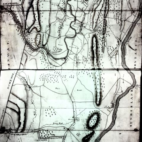
David Hoyt, Jr. created this map of Deerfield in 1794, the same year the Massachusetts Legislature ordered every town in the Commonwealth to “take or cause to be taken” accurate plans of their respective towns, including rivers, bridges, roads, and houses for public worship. A trained surveyor, Hoyt carefully marked the boundaries of Deerfield, Massachusetts, as well as the network of roads, and ferries across the Deerfield and Connecticut Rivers. At this time no bridges existed across either river; the Old Albany Road west of town continues across the Deerfield river at a ford or shallow spot in the river. The map also notes the locations of mills, and differentiates their type by symbols. Deerfield appears as the sole settlement, although numerous outlying houses and farms existed. Hoyt’s pictorial representation of hills to the east and west dominate the landscape and give an impression of rugged terrain.
Hoyt, Jr., David. Plan of the Town of Deerfield. Map/Plan. 1794. Pocumtuck Valley Memorial Association, American Centuries. https://americancenturies.org/collection/l98-011/. Accessed on March 27, 2026.
Please note: Citations are generated automatically from bibliographic data.