Maps, charts, and drawings present a great deal of information in a visual format. Two early maps depicting Deerfield, Massachusetts, offer interesting evidence of the history of the town. One shows the town as it was in 1794. The second map was created 36 years later, in 1831. Comparing them reveals changes in the town and surrounding landscape over a 36-year period.
Both maps are details of larger works and were drawn by hand. In each case, the creator decided what he would include and what perspective he would take. Note that both seem to have been drawn from a hilltop to the east of the village. Perhaps both map makers really did climb the hill to make a sketch of the town’s buildings and the path of the Deerfield River.
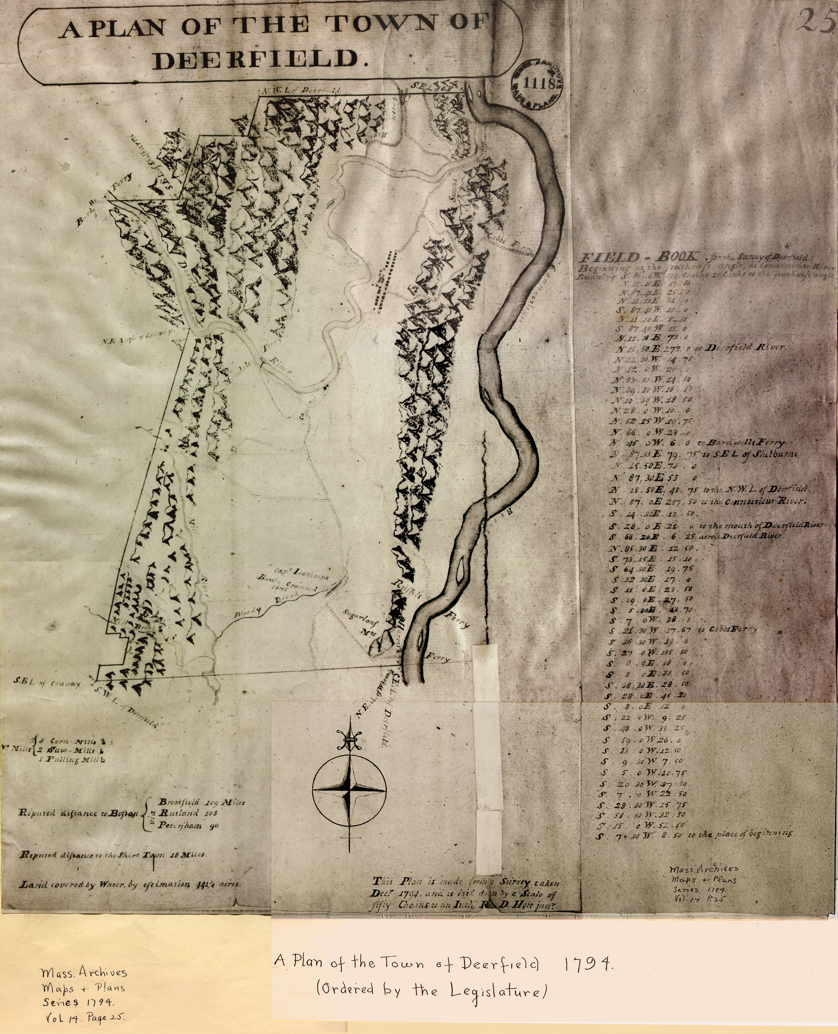
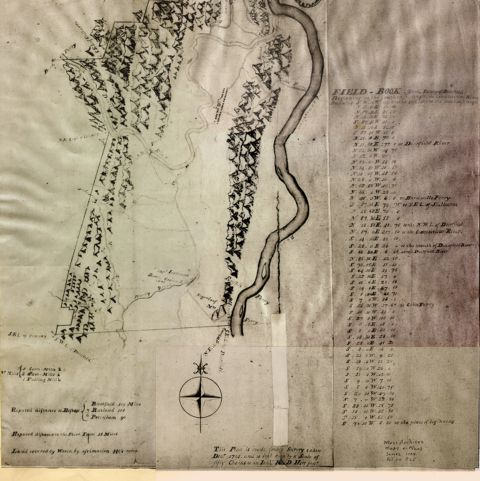
David Hoyt, Jr. (1757-1803), a trained surveyor, innkeeper, and farmer, executed a plan of the town in 1794. Was he asked to draw the map, or did he draw it for his own pleasure? The answer lies in a document filed with records of Deerfield Town Meetings, dated June 18, 1794. The “House of Representatives of the Commonwealth of Massachusetts” ordered Selectmen of all Massachusetts towns to “take or cause to be taken” accurate plans of their respective towns upon a scale of two hundred rods to an inch [16 feet=1 rod] including rivers, bridges, roads, and houses for public worship.

Hoyt’s map shows how Deerfield, in common with other early English settlements along the Connecticut River, was laid out in a linear pattern along a broad street. The main village was located on an alluvial plain between rising hills to the east and west. We can count 34 small squares, representing buildings, and a steepled meetinghouse in the center of town on the west side of the street. In addition to buildings, Hoyt defined the roadways that led out of town – over the Deerfield River, over the mountain (Pocumtuck Ridge) and both north and south into the common fields and beyond, north to the town of Greenfield. His map included names and locations of ferry crossings at the Deerfield and Connecticut Rivers (there were no bridge crossings in 1794.)

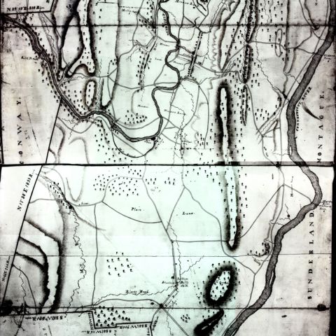
In 1829, the Massachusetts General Court again requested that each town in Commonwealth create a map. Arthur W. Hoyt (1811-1899), a nephew of David Hoyt, Jr., drew the map of Deerfield. Only 19 years old at the time, Arthur was in the process of becoming a civil engineer. In contrast to his uncle’s earlier map, the mountains of Arthur’s 1830 version are less dramatic, depicted more as woods, represented by stylized trees.
The roadways in the 1830 map are like those in the 1794 version, with a few additions into the north and south meadows. Note, however, how the path of the river has changed, leaving only a small meander compared to its course only a few decades earlier. Changes in course of the Deerfield and other waterways are generally caused by floods, serious storms, or human activity. Evidence of such changes may be found in town records, newspapers, or in private papers such as correspondence and diaries. For example, Epaphras Hoyt, a Deerfield resident, shared in a public lecture in 1839 how the Deerfield River had shifted since his youth: “Changes in the channel of the River, in various places, have been great, especially opposite to the middle Lane, the south end of the street, and north of Pine hill, by abrasions of the bank.”
An increase in the number of structures depicted in the main village revealed an increase in population. In 1830, Deerfield’s main village street now identified a district school, as well as a private “Academy” on the north side of the road toward the east mountain. This was the first home of the Deerfield Academy, founded in 1797, and opened January 1, 1799. The building, designed by American-born architect Asher Benjamin, still stands and is currently the Memorial Hall Museum of the Pocumtuck Valley Memorial Association. Arthur Hoyt’s map also confirms the expansion of the town’s population outside of the original settlement of Deerfield, documenting the growth of the communities of Mill Village, Wapping Village, Bloody Brook (present-day South Deerfield), and Cheapside. Additional roads, the construction of bridges to replace ferries, and an increasing number of schools, academies, and meetinghouses indicate a greater degree of services for inhabitants.
Curiously, Arthur Hoyt’s map shows no buildings on Albany Road, which leads from the center of town to the Deerfield River and beyond, although the town history reveals that five houses and shops were built there in the years after 1760. The way he has spaced the buildings suggests a true rendering, however, with some close together and some farther apart, as we can confirm for structures that have survived to the present day.
By 1830, the town had a new place of worship. The Congregational Church was the state-supported, established church of Massachusetts until 1834. Anticipating this change, the brick Greek Revival meetinghouse Deerfield built in 1824 was the first to be used “solely for worship.” Although it appeared to be in the same general location on the Deerfield town common, the building, which still stands, is in fact located just off the common to the north.
Both the 1794 and the 1830 maps offer valuable information at a particular moment in the life of a town. Pairing the two maps documents changes in the town and surrounding landscape over a thirty-six year period. Pairing the 1794 and 1830 maps with a modern-day plan of Deerfield and the surrounding region can provide additional interesting information about the growth of a New England town and changes in the landscape over 200-plus years.